Sunday, October 30, 2011

Global Positioning what???

New Wild Coast map blog is two down ...

One of the most frequent questions with which I am assailed by both my fans is this: do you think maps are still relevant in this techno age of GPS and Google Earth? - and if so, why?

I reply [with no hint of bias], "Of course they are!"

An outstanding feature of the age of techno is how easily we humans are seduced into believing wrong stuff about our newly-invented tools (because that's what all these gaudy gimgaws are - just tools, like hammers or stone hand-axes). People once believed that computers would be the end of paper documents. They believed that newspapers would disappear in the face of the internet. They still believe that using a credit card on the internet is dangerous, whereas it's actually the safest place you can use one. People believe that GPS machines are infallibly accurate. They believe that cellphone mast-transmissions will cause babies to be born with four legs, and some even believe that the Chinese are civilized.
Great for tracking Afrika ...

GPS stands for "global positioning system" and it relies upon bouncing radio signals off fixed-orbit satellites to "triangulate" or calculate, by fairly simple mathematics, exactly where you are on the planet. There are two types of GPS machines - those that record a track of your movements in relation to the Earth's surface, and those that are pre-loaded with tracks or points so that you can punch in a placename and the machine will [theoretically] direct you to it. It's often supposed to to do this via the shortest route, but don't hold your breathe.

A map, by contrast, is a picture of a part of the Earth's surface that helps you to see one place in relation to another.

I repeat: "that helps you to see one place in relation to another."

In a nutshell, a GPS reader will direct you to a place whose name you already know and which you want to get to. It won't tell you what's on the other side of those mountains. It has a dinky little screen with a teeny-weeny little maplet on it, but it's like looking through a keyhole. A map, on the other hand, is a magnificent sheet of paper filled with information about roads and mountain ranges and towns and places of interest, and you can spread it out on the table and see all these marvellous things at a glance and how they relate to each other.

Don't try spreading this out across your table ...
You can't spread a GPS reader out on the table unless you use a rolling pin, which might be expensive and not really what you intended.

People forget that, just as maps are only as good as the cartographers who drew them, GPS readers are only as good as the info which a human being pre-loaded into them. They often hold massive amounts of info of which lots and lots is incorrect. Of course it is - they are programmed by humans! They contain massive amounts of data, and they overcome the "error" problem using a simple principle.

It's the same principle that's used for street atlases for large cities. The atlas/GPS assumes that, of the millions of possibilities available, you are only going to use a really small fraction in the lifetime of your atlas or device. If the info is 80 - 90% accurate, your chances of coming across errors are pretty miniscule; your chances of finding more than one error are even smaller, etc etc.

You should also be aware that the global GPS system is getting old and creaky these days - it's all-American in origin, and pretty short on fine detail. Europe is busy developing its Galileo system - the first satellites have already been launched - that will be 20 times more accurate than GPS. Find space in the attic for that old Garmin!

In the end, it's a simple equation. You use GPS to find a known destination; you use a map to explore, to find new, unknown places, to discover the gobsmacking hidden beauties of our wonderful land.

And when you've used your map and discovered those beauties, you can track them and put them on your GPS so that you can find your way back again. Me, I do that by looking out of my car window, not peering at my TomTom. It's much more fun!

Kaartman, 30 Oktober 2011

Saturday, October 22, 2011

Finders Keepers

 New Wild Coast map - next blog down!

One of the benefits of map making is that you get to hike and travel a lot - and one of the side-effects of hiking and travelling a lot is that you get to find stuff.

Unexpected stuff, sometimes.

For years we used to spend the New Year weekend camping on a bit of private land on the banks of a large lagoon. The General Public were pretty much confined to the other bank, about four km away across the water. Their Bank was upwind of Our Bank, and most days we'd trawl up and down the lagoon edge finding all sorts of washed-up stuff the GP had inadvertently dropped into the water - hats and beach balls and even buckets and spades. We had a rule that always worked - if you found a shoe / plakkie / boot etc, within 100 metres you'd find the other one - hurled into the water, no doubt, by a pissed-off owner who thought that having only one shoe left was no use at all.

Once, on a rare change-of-wind, one of our kids lost his beachball - it sailed away until it was nothing but a teeny weeny little dot in the watery distance. Floods of inconsolable tears followed. Exactly one year later the same ball - it had his name on it - sailed back to Our Bank and was retrieved, with whoops of joy.

Sowaar.

One day we thought there was a body in the water - oh dear - but it turned out to be nothing but an old leather armchair. How we mistook an armchair for a body [or how it got lost in the lagoon!] is another story, but after we'd dried it out it was a great addition to our summer campsite.

Then there was the time we stopped to admire the view from the top of Middelberg Pass, near Citrusdal. Opened the car door and there, on the ground, was a brand-new R100 note winking at me. Much discussion followed, involving fantasies of down-trodden women tramping dusty miles to the town clinic with a ragtag of sick kids, losing her last R100 ... so we stopped at Tulbagh and enjoyed a reasonably slap-up meal, R100 being worth a bit more in those days.

This looked like becoming a dangerous habit when, a couple of years later, we stepped out of the car at Leipoldt's Grave in the Pakhuis Pass. There on the ground was a brand-new R100 note. This time we naively asked some other quite dishonest-looking people who had also parked there whether they had lost any money.

"Yes," they said (a bit too eagerly, I thought), but we handed it over at once, something we've regretted ever since. They for sure were NOT down-trodden women with a ragtag of sick kids ...

Near the Heuningvlei donkey trail - can you locate this for me?
Most extraordinary of all, though, was my son's find. He was recently walking one of the most isolated paths in the Cederberg, doing some mapping for a new map [more exciting news later], when he and his mate stopped for a rest. My son pulled off the path and sat down on a lonely rock, miles from nowhere, and found ... a real-live Blackberry.

Well, it wouldn't work, of course [this was before the whole world's Blackberry's crashed, by the way], but he eventually reached base camp where, in a flash of brilliance, he extracted a flash-memory card from the thing. We plugged the card into our laptop ... and the card worked, revealing a plethora of folders. These included photographs and we brightly realised that there might be photos of the owner's very own Cederberg trip on it. Sure enough, there they were, horribly low-res but I guess that's a Blackberry for you.


The photos had file dates, of course, so we were able to trace the owner through the bookings at the Algeria office. The Blackberry had sat on its rock through rain and shine, snow and heat, for about three months. Whether it ever worked again I do not know - the owner eventually collected it - but it had been chewed by some small animal. Shame hay, imagine living in the deep Cederberg all your life and stumbling upon a delicious blackberry - only to find that it's made of Chinese plastic, after all.

Bremer, the owner, was a young fellow so filled with amazed gratitude that he wrote a letter and sent a box of chocs.

"Ek wil net dankie sê vir u, vir u menslikheid ... die storie het onlangs my gunstelling een geword; ek het al naby aan ’n 100 mense vertel -- my ma het al meer as 200 mense vertel."

Feels to good to know that not only did we find and return the Blackberry, we gave Bremer and his ma a story to dine out on many, many times ... not like that poor little Cederberg mouse or whatever. Hope he didn't get indigestion.

Toothmarks on B² 's Blackberry


It's my birthday today, I hope both my fans will share my happiness at being another year richer in life, love and lots of good stuff.

-- Die Kaartman, 22 Okt 2011

Friday, October 14, 2011

Wild Coast edition 3

The sad thing for me about the production of Wild Coast edition 3 is that I wasn't able to get up there myself, wandering around those awful roads and that absolutely stunning, achingly lovely countryside.

BUY THE MAP AT
www.slingsbymaps.com
In fact I hadn't imagined that there would be all that many changes, but I'd hardly dusted off the old edition 2 files and got 'em up on the screen when the announcement came through that, in order to enrich all sorts of people with the right political connections and, in complete disregard of the opinions of the local residents and every environmentalist on the planet, the Minister of Environmental Affairs, the Honourable Edna Molewa, having applied her mind, had approved the construction of the N2 "Pondoland" Toll Road.

Avoiding the temptation to refer to the Hon Minister as Edna Bucket I realised that the new edition of the map would at the very least have to include the route of the proposed road ... which a quick google search provided. I made it fairly prominent on the map, hoping that that ugly scar across the landscape might touch a few consciences and even maybe [fat hope!] get some heads out of some buckets.

Then I had comprehensive info from Roger Galloway and Clive Dennison about stuff that needed changing.

Clive is well-known for his books about the history of the area, and he gave me some good info about airstrips and other great bits and pieces.

Roger gave me excellent info about newly-tarred and upgraded roads, names of clinics, etc. Roger heads up the Wild Wild Coast, an organization that promotes environmental education and awareness in the Zithulele area south of Hole in the Wall. He manages the Mbolompo Homestay as well and is closely linked to the Jabulani Foundation ... names, names ... but what Roger does is similar to the fantastic work done by Dave Martin of Bulungula and Aidan Lawrence of Wild Lubanzi. These three ous form a triumvirate who not only provided fantastic, clear and helpful info about their part of the Wild Coast, they are also all involved in the most constructive and inspiring community programmes imaginable.


Over the years, through the mapping we've probably come across 2000 to 3000 accommodation establishments of all kinds, from the simplest of camp sites to huge larnie 5-star hotels. The number of them who run community-based programmes or even, let it be said, appear to give a fig about the poor and needy in their areas can be counted on the fingers, maybe of both hands, and the toes of one foot. The Galloway/Martin/Lawrence experience was like a breath of very fresh wild sea air. Go for these websites to find out more [and contribute too, if you can!]

www.wildwildcoast.com
www.bulungula.com
bulungulaincubator.wordpress.com
mbolompohomestay.weebly.com
www.jabulanifoundation.org
www.lubanzi.co.za


David Kramer wrote poignantly about the effects [or lack of them] of tourism on some areas in his "Dans Mettie Dood", a provocative, poetic song about the despair of poverty ...

Mense kom van oorie see
En die Boere bou net b en b ...
Hylle ry op en af met kameras en vier-by-vier ...
Almal is op soek na die ou Karoo;
As jy daai wil soek, kyk hier in my oë ...
Wêreld verander voor jy jou oë uitvee

Then I found that in northern Pondoland our road info was pretty inadequate ... after discovering the Mtentu River Lodge I discovered a whole spiderweb of little roads that should've been on the map, so there they are now. How we missed this lodge on our first maps I dunno ... but I wrote to the guys there to apologise ... still don't know their names, they just call themselves "the team". Poor guys are horribly close to that toll road ...

www.mtenturiverlodge.co.za


At this point our original First Researcher, the invaluable, indefatigable and ever-helpful Gavin Stewart stepped up to the plate ... he uncovered Denver Webb, who gave me great stuff about old battle sites. Try these Google Earth coords - them ancient forts are still there, if only as patterns in the ground under ploughed fields ...


Fort Beechamwood:
32 19 52.24S 28 42 20.65E


Fort Owen [near Centani]:
32 28 37.63S 28 16 30.25E


Gavin also unearthed and dusted off Craig McLachlan of the Eastern Cape Dept of Public Works, who passed on fantastic info about the proposed upgrading of various roads and the dates - so the map will stay up to date a little longer!

Finally, Laura Mileham helped update the Jikeleza Route insets on the map, with lots of interesting new stuff.

All that was left was a complaint passed on by Kob Inn's Daan van Zyl ... that the GPS coords on the map were wrong. Well, that just ain't true - they are and always have been 100% correct!

What's wrong is that users of Tom-Toms and other machines - which, by the way, are only as good as the human-drawn maps that are preloaded into them - can't distinguish between coordinates given in degrees, minutes and seconds, and coords given in degrees and decimals of degrees. I have changed them to degrees, minutes and decimals of minutes, however, on the new map, because that's the way most modern GPS readers are preset, and if anyone tells you they are wrong, they are simply mathematically inept and ought to go back to Grade 5. And that's that.

- Kaartman, 14 October 2011

Monday, October 10, 2011

Da lie [about Tibet]

I nearly pulled my previous post when I read a letter in today's Cape Times from Sydney Kaye. Kaye quite rightly pointed out that "old" Tibet [ie before the Chinese invasion] was anything but a land of sweetness and light - it was a savage, barbaric medieval fiefdom run by religious despots and aristocratic clans, rife with semi-slavery, systematic sexual abuse of the poor, mutilation of "criminals" including such gentle Buddhist practices as the putting out of eyes and chopping off of hands, etc etc. The religion cheerfully justified all this savage repression with the following [I quote]: "The poor and afflicted brought their troubles on themselves because of their wicked ways in previous lives and had to accept their current miseries as atonement, in anticipation of a better lot in the next life." God, religious oppressors have such convenient dogmas, hay. Presumably the fat-cats were those who had lived amazingly pure and blameless previous lives and their reward was to be able to kick the peasants around. May bucket loads of vomit be poured upon your re-incarnated heads, you bunch of sh*ts.
I wondered whether Archbish Des had ever discussed these charming aspects of Tibetan cultural and religious life with the man in the big square specs.
When I had calmed down, however, I realised that even though the state of old Tibet was hardly improved by the bloodthirsty Chinese savages taking over and liquidating everyone they didn't like, it still didn't change the fact that both Clayson and Kgalema lied to the people of South Africa, thus putting themselves out with the rest of the political rubbish with which history is sadly littered.
What has this got to do with maps? Well, Tibet is in the Himalayas, right? And they are the highest mountains on Earth, right? I rest my case.
- Kaartman, 10 October 2011

Thursday, October 6, 2011

Cartopolitik

Anyone who thinks that map-making has nothing to do with politics needs to think again. My very first blog had to do with that unspeakable Egyptian Mubarak being thrown out of power, by his own brave people. Politics is about countries, and countries are boundaries and geography and maps. Kaartmanne like me make maps for tourists: good politics = good tourism. Look what happened after 1994. Floods of overseas tourists; so many that we started making international-standard maps for all those wonderful dollar- and pound-bearing people. But bad politics = bad tourism. At the moment we're going through about as rotten a bout of politics as we've ever had in the whole history of our Beloved Country.
    I'll explain. Tutu said [I don't always agree with the Arch, but this time I certainly did] that the ANC-govt action regarding a visa for the Dalai Lama was worse than any similar action by those disgusting, racist Nationalists - because at least with the Nats you knew before you planned anything that they would respond in a disgusting, racist way. It was the only way they knew how. But the ANC? They were supposed to be liberators, democrats, filled with sweetness and light and literally ponging of righteousness, of resolve to help the poor [or, as they say ad nauseam, "the poorest of the poor"] and downtrodden peoples of the world. Instead, they obfuscated, cringed and crawled in a really very disgustingly obsequious way to Earth's new imperialists, savage oppressors of Tibet and any other minority nation that stands in their way [like South Africa?] - the savage, barbarian Chinese government.
    The words "savage" and "barbarian" are the only words in the English language that are appropriate for any self-appointed, unelected government - see below.
    I heard Richard Branson on the radio this evening. Virgin Dick [as he is fondly known in some quarters] banged on about Mandela and what a great guy he was, and how the world would view our government's actions over the Dalai rather poorly. Richard saved the bankrupt Health and Racquet club, remember? But Richard missed the same point that Arch-Bish-Emeritus Tutu did, a point none-the-less picked up by some of the sharper and braver radio commentators of our day: with regard to the Dalai Lama and his Visa, our Government, quite simply, lied to its own people.
Two GREAT South Africans: non-liars!!!
    Specifically, Clayson Monyela, spokesperson for the "Dept of Foreign Affairs" [sorry, it has a new handle for reasons that no one understands], lied - as did the oh-so dishonourable Vice-President Kgalema Motlanthe.
    Which is bad news for anyone who thought that Motlanthe, freshly returned from shoving his distinguished head firmly up a savage, barbarian Chinese fundament, might make a suitable substitute for the other lip-licking philanderer who currently occupies the hot seat.
    The only other President we've ever had who licked his lips like one of those poisonous desert lizards was ... PW Botha. Remember that?
    Now, I can't remember who said it, and if someone out there can help me I would be delighted, but what they said was, "When a government lies to its own people, its demise is certain - and, no matter how long it takes, its downfall will come as sure as night follows day."
    This I hold to be self-evidently true. There is no repressive regime in modern history that has lasted for more than a few decades at best. All repressive regimes lie to their people - by their very nature they have to. Hitler, Stalin, Breshnev, Pol Pot, Idi Amin, Franco, Mubarak, Gaddafi, Reza Shah, Hirohito, Mussolini, Pinochet, PW Botha ... how many more have lied to, insulted and upset and abused us [their citizens], and are now gone for ever? Where are they now [apart from being stone dead, thank God]? They are all in history's trashcan where they absolutely belong. No one on today's Earth has a single good word to say for any of these freaks ... except maybe a few freaks. The history books will sure as hell have nothing good to say for them, either. Ivan the Terrible, Emperor Nero, Oliver Cromwell, Louis XV - these ous still get a bad press, hundreds of years after no one can even remember the horrible, crappy things they did to their own people.
    So that's the real problem. Lying to us about the Dalai Lama's visa might seem like a small thing, but it's all part of a larger picture whereby the ANC - a once-noble liberation organization - has ultimately condemned itself to the same oh-so-filthy historical trashcan. To see that larger picture, consider this: what do the governments of unelected savage barbarians [individuals who impose themselves on their own populations without choice are by definition bullies and therefore savage barbarians - see above] like Muammar Gaddafi, Robert Mugabe, China's Hu, North Korea's [?] [- should I bother?], Castro, King Mswati, that awful ou in Equitorial Guinea, Assad in Syria, etc etc have in common? Well, they're all deposed and/or hated and despised by their own people - that's one thing they all know they have. The other thing that they can fondly embrace is that the ANC - our governing party, the party of the people who run and seem, almost daily, to want to ruin our beautiful, proud land - snuggles up to all of them, without exception.
    And you can bet that if there is a single other foul, repressive, unelected barbaric savage repressing his/her own people anywhere in the world, our ANC government loves them too.
    There you have it - liars, liars, liars. And the Freedom Charter ... in tatters?

Wednesday, October 5, 2011

On the Naming of Names

One of the most enduring controversies that a mapmaker has to put up with is the question of names. Place names: town names, farm names, mountain names, river names, all sorts of names on a map cause concern, sometimes rightly so, often because the objector confuses the role of the map and the mapmaker as far as names are concerned.
   Where do place names come from? Most of the time they just seem to "be there", and we don't have to think much about them. Some might strike us as odd ["Douse the Glim"] or funny ["Hotazel"] or even almost rude ["Pisgoedkraal"], others are ... well, just names.
   Most of the oldest names in the world are simply descriptive. Hence you find a name like "Karoo", an ancient San word meaning "Flat, dry place". Some come from legends that arose in the mists of the past: Rome, from the legend of Romulus and Remus. Others simply arise from geography: Cape Town. Colonisers annoyed the colonised by importing their favourite names from the home country, and these soon got thrown out when decolonization took place: Salisbury in Rhodesia became Harare in Zimbabwe.
   Powerful political figures named towns after themselves or their family members: scores of Cape villages were so named by long-forgotten Dutch and British governors and other apparatchiks: Clanwilliam, Malmesbury, Simon's Town, Somerset West [and East], Barkly East [and West], Riebeeks West and East, Stellenbosch, Oudtshoorn, Cathcart, Swellendam, Tulbagh, Wolseley, Wellington ... or local dominees, like Moorreesburg or Robertson or Sutherland. How many people know that Hopefield is named after two very ornery civil servants: Mr Hope and Mr Field?
    All of this ignores the traditional and ancient role of mapmakers in naming places on the earth, often whose shapes and contours and relationships they first deliminated. The Americas, the Pacific Ocean, Australia, Ethiopia, India, the West Indies are just a few examples of some of the places you may have heard of whose contemporary names first appeared on maps, named by the mapmaker.
    Which is where the controversy comes in. I have put names on maps and later been asked, "How dare you give that place that name?" I've always replied, "Well, what is its name, then?" Reply: "It has no name, but you have no right to give it a name!"
    Many years ago I knew a ranger named Dick, who was in charge of a well-known nature reserve. Dick named a rock formation "Lizzie's Leap" after his wife, and a waterfall "Fryth's Falls" after a daughter. What Dick hadn't reckoned on was that this display of family loyalty inevitably led his colleagues to rename a local, particularly tumescent rock pinnacle [known boringly as "The Pinnacle"] after Dick himself ... I'll say no more.
   So, who should be allowed to name a place: a river, a mountain, a funny-looking rock, a street, a campsite? There is not one among you who does not assume the right to name her or his own house or farm or factory or business enterprise with the name of your choice - and rightly so. But if you had named your farm Bloemfontein or Mitchell's Plain or Constantia, or named your favorite holiday campsite after yourself [Hermanus or Herold or Camp's Bay], what gave your choice the right to be enshrined as the place name of a dorp, a town, or even a city?
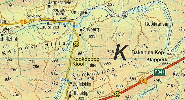
    Sadly, lots of these "given" names eventually disappear with their owners; one of the things we try to do is to enshrine old farm names on our maps, so that they do not die. Here's a part of the Swartberg with a couple of just-such, intriguing names ... I assume that "Kabooka" and "Kookooboo" are derived from old Khoi names.


    Some would say: a name has to evolve, it has to come from what Afrikaners rather well-describe as "die volksmond" [the voice of the people]. That's a funny idea to me; the excellent Afrikaans descriptive sadly leaves a trail of hundreds of Grootriviere ["big river"], Kleinriviere ["small river"], Rietfonteins ["reed fountain"], Spitskoppe ["pointy peak"] etc etc in its wake. My favorite farm name is that of a wheat farm near Moorreesburg. Its name? "Koringplaas" [wheat farm], proudly carried on a sign at the side of the N7 highway. Not far away is a sheep farm named "Skaapkraal". The voice of the people is not always, shall we say, the most creative or illuminating voice around ...
    Others say, we need a democratic decision. Well, it has taken the City of Cape Town more than ten years to rename three streets in a "democratic" process, so maybe we should laugh that one off right away. They say a camel is a horse designed by a committee, and the same process seems to true for placenames. That said, one wonders at the sheer arrogance of the Nationalist Government's "Place Names Commission" that decreed, without a moment's reference to the wishes of the towns' inhabitants, that Simon's Town should be Simonstown, Wupperthal should be Wuppertal, and Onrust should be Onrus ... they later caved in on Simon's Town because the SA Navy wanted it so, but the other two are still "officially" known by the names that their inhabitants reject. What arrant nonsense!  Sadly this "commission" still seems to exist somewhere, and it's just as arrogant as ever.
    The other recent form of "democratic" naming seems to be that applied to informal settlements, many of which sport highly descriptive if uncomplimentary names. But I always wonder how our worthy struggle heroes must feel about some of the poverty-stricken places named after them ...
    Every noteworthy place deserves a name. Names provide us with a geographic framework so that we can put places into their correct relationships with each other. We don't each have a built in GPS and, if you think about it, it would be pretty awful if we identified places by their long/lat coords! "Where are you off to on holiday this year?" "Oh, we thought we'd go to -32.001894S 22.319672E for a change - lovely beaches!" 
    The mapmaker, though, often has a problem - he needs to identify a landmark to help the traveller, whether a motorist or a hiker. It has no name that he can find ... so he gives it one! 
    Recently in the Cederberg we identified a few such places - the purists will be shocked. But if they have better names for Seven Waterfalls, Black Falls, Squat Rock and several other noteworthy features, we'll be glad to hear from them!
    There's a powerful safety angle involved here. A hiker's map with a dearth of names is a dangerous map, because the verbal description of a locality, especially in an emergency, becomes very problematic. "My injured friend is about 500 metres from the path near a big rock that looks like an apple, but from the other side it looks like an upside-down banana" is so not-gonna-make-it compared to "My friend is ten metres from Apple Rock - there, on the map."
    And if you prefer to call it "upside down Banana Rock", well, that's your democratic right, and we hope you'll soon publish your own map too!
-  Kaartman, 5 October 2011