Thursday, January 27, 2011

Die Saaie

If you hate the Laingsburg-Beaufort West stretch of the N1 like any normal person, there's an utterly delightful way of getting to Prince Albert "off the tar". Turn off the Ladismith road from Laingsburg at the Floriskraal Dam turn-off and head eastwards. You need a vehicle with a reasonably high clearance, but 4x4 isn't strictly necessary. You also need a willing co-driver to open the gates; there are 22 of them on the 150km to PA. If your passenger complains, tell them to think about how fit all that hopping in and out of the car is making them.

Don't be put off by the game farm gates that are plastered with "Private" notices - it's every inch a public road. Just shut the gates behind you, that's all.

The road runs up a long valley north of the Witteberg, the foothills-range that marches with the Swartberg from west to east. Before the Dwyka River the valley is known as the Agtersaai. There are two "saaie" - the Voorsaai and the Agtersaai, so named because the Karoo geology has caused the vegetation to grow in long rows, resembling seed-sown farmlands. The Doekberg separates the two Saaie - "doek" literally meaning "screen", because the hills screen the view of one Saai from the other.

Lekker names, hey?

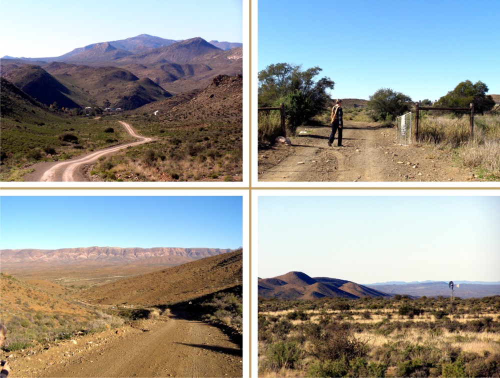
Top left: Floriskraal; Top right: Gate 11
Bottom left: Witteberg from the Doekberg; Bottom right: Agtersaai


About 43 km from PA you have to cross the Dwyka River, but the drift is usually dry or very shallow. We watched a brace of spoonbills gaggling about in the mud there; odd birds with very odd beaks. "Dwyka" means salty or "brak" river; it's a Khoi name, probably ancient, and it's a tributary of the Gamka or "lion river".

When we told an acquaintance that we were mapping the Swartberg he was furious. He'd just bought a retirement cottage in Prince Albert and was looking forward to quiet times. "Your *** map will bring hundreds of noisy tourists, you ***", he said.

He should have counted the places to stay in PA before he bought his cottage. There are nearly fifty of 'em with hundreds of beds, all opened long before we thought of a map ...

Shame, hey.

Does anyone know the name of the RDP township at Prince Albert? We couldn't find it anywhere ... the PA Tourism Bureau's website ignores the former "coloured" township entirely - even the PA Primary School is not listed as a local school! Seems a bit Old-RSA, but there it is.

Thursday, January 20, 2011

Floods ...

January 2011 has been a terrible month for floods ... floods in Sri Lanka, Australia, Brazil, and even here in Pretoria, Upington and Natal. Thousands have lost everything they possess, hundreds have lost their lives. It's easy to forget that exactly thirty years ago, on January 25 1981, there was a flood in the Karoo so violent that engineers described it as a 'one-in-two-thousand-years' event. An incredible 200mm of rain fell in just eight minutes on the already-sodden Moordenaarskaroo, and a wall of water tore down the Buffels River. In minutes it destroyed more than half of the little town of Laingsburg, and over a hundred people lost their lives.

If Laingsburg had been the size of present-day Cape Town, the number of lives lost would proportionately have been nearly half a million ...

We started the research for our map of the Swartberg and the Little Karoo in 2009, but in reality it started much, much earlier. In 1991 - ten years after the flood - we visited Laingsburg to confirm details for a novel I was writing about the flood. We stayed in the Laingsburg Hotel, its passages hung with poignant photographs of the disaster, of distraught people, helicopters, destroyed homes. We drove down the Ladismith road to the Witteberg Bridge, and out on the farm road to Geelbek, seeking locations along the river for our tale. The bone-dry bed of the Buffels River was several hundred metres wide, showing flashes of colour between the karoo-brown stones - bits of motor car, here a mangle, there a kettle, here a piece of old, brass bedstead. Ten years after the flood the signs were still everywhere, even to the mats of dried grass in the very tops of the surviving trees.

I've spent most of the past week mapping in and around Laingsburg, deliminating its contours and its dry river bed, its bustling National Main Road, its sleepy township named by the locals after the huge sign, picked out in white stones on the dry hill behind the town - 'Dra Wol' ('Wear Wool'). It's been a memory trip, reminding me of the flood and the story I wrote. Every now and then I've snatched a look at Google Earth, too. If you thought the Karoo was a desert, have a look at Google Earth - almost every inch shows that this is a region subjected - albeit rarely - to extreme floods. Go to -33.1732; 20.8877 and zoom down to 2.5km for an example that's just north of Laingsburg!

There's a lot more work to do on the map, but we're still hoping for publication by Easter - more later.

The novel was 'Flood Sunday', originally published by Tafelberg, now out of print (it went to three impressions!). We're hoping to get a pdf version up on the website someday! Here is one of Ann Snaddon's brilliant sketches for the story ...


- Kaartman, Thursday, http://www.slingsbymaps.com/

Oh yes, here are a couple of useful links if you want to know more ...

http://saweatherobserver.blogspot.com/2009/10/laingsburg-flood-25-january-1981.html

http://www.sahistory.org.za/pages/chronology/thisday/1981-01-25.htm

Molly commented:


Lovely post! Very excited to see what happens in this space - well done. x
By Molly on Floods ... at 9:19 PM